
SHOPPING | CONTACT | NEWS | SUBSCRIBE ENG ITA ESP ENG ITA ESP Catene de Containers in Le Havre, how to get there, what to do and see Catene de Containers Share on facebook Share on pinterest Share on twitter The Catene de Containers is a work by Vincent Ganivet, a multifaceted French artist, originally from Suresnes. His work was inaugurated in 2017, during the celebration of the 500th anniversary of Le Havre. Positioned between the city and the sea, the work is made up of giant containers, all colored, arranged one on top of the other, to form two monumental arches. A total of 36 containers, divided into 21 and 15 for each arch, which symbolize the maritime and commercial vocation of the Norman city. Walking along the harbor, the glimpse of the Catene de Containers is truly incredible. A truly monumental work that, however young it may be, has become the symbol of Le Havre. We like it for its uniqueness, for the shapes and, above all, for the explosion of colors. PRACTICAL INFO HOW TO REACH THE CATENE DE CONTAINERS The work is located in Chaussée John Kennedy, at the port of Le Havre, right in the center. You can easily reach it on foot. Gare du Havre, the central train station, is just under 2 kilometers away. From the station, by tram (lines A and B) you can easily reach the center. Buses 2, 7 and C2 allow you to easily reach the port. LiA public transport is quite frequent and reliable. It is not recommended to use a car to reach the port. TIMETABLES, WHAT TO DO AND SEE The work is a free installation, accessible free of charge all day, 24 hours a day. Located in Chaussée Kennedy, it is an excellent starting point for visiting the port. Along Quai de Southampton you can stroll and relax. Ideal place for sports, for skating or running. The final observation point on the port and the ships arriving and departing is beautiful. The MuMa, just nearby, is an interesting Museum of Modern Art, where you can admire 5 centuries of art and a large Impressionist section. Related Leave a comment Latest Posts Map of the Place Share the Post Share on facebook Share on twitter Share on linkedin Share on pinterest Share on email

Hosier Lane
SHOPPING | CONTACT | NEWS | SUBSCRIBE ENG ITA ESP ENG ITA ESP Hosier Lane, Melbourne. Most colorful places in the world. Info, guide Hosier Lane Share on facebook Share on pinterest Share on twitter Hosier Lane is, without a doubt, one of the liveliest and most colorful places in Melbourne. One of those roads that hardly go unnoticed. It is, at the same time, one of the landmarks of Street Art, thanks to the numerous art installations on the street walls. A restyling project completed in 1998, thanks to the City Line Initiative. Today it is considered a must see on a Melbourne holiday. Many insiders describe it as a sort of open-air museum in the field of Street Art. The art installations, graffiti and murals are a true riot of colors. Images that, overwhelmed, alternate with messages, most of which have a political background. Many do not fail to be immortalized against the background of the walls of the most famous street in Melbourne. If you also find yourself in these parts, we are sure that you will not miss this opportunity. PRACTICAL INFO HOW TO REACH HOSIER LANE The lively Australian street is in the center, so you can easily get there on foot. The street is located along Flinders St, just a few minutes’ walk from the beautiful St. Paul’s Cathedral. You can also arrive by public transport, using tram lines 35, 70 or 75. You will need to get off at Russell Street – Stop 6. After a couple of minutes of walking you turn right and you are there. WHAT TO DO AND SEE In addition to delighting your view, Hosier Lane is a lively meeting place with bars and plenty of clubs. At the Good 2 Go you can enjoy excellent muffins and long black coffee (for lovers). Spanish and international cuisine await you at Movida, at the beginning of the street. Related Leave a comment Latest Posts Map of the Place Share the Post Share on facebook Share on twitter Share on linkedin Share on pinterest Share on email

Tenby Castle Beach
SHOPPING | CONTACT | NEWS | SUBSCRIBE ENG ITA ESP ENG ITA ESP Tenby Castle Beach in Wales. City most colorful places in the world Tenby Castle Beach Share on facebook Share on pinterest Share on twitter Along the south coast of Pembrokshire lies one of the most beautiful and characteristic villages in Wales: Tenby. Nestled in Carmartehn Bay, Dinbych-y-Pysgod, (its name in Welsh) is a delightful and charming village, steeped in history. Formerly a fishing village. You can admire the splendid Museum and the Art Gallery, the Tudor’s Merchant House. Cliffs and fortified walls of the twelfth century. But it is from the sea that you can admire all its beauty. From Tenby Castle beach, and South Beach, the view becomes absolutely spectacular. On the one hand, not too far away, the sacred island of Caldey Island. On the other hand, the splendid pastel-colored buildings. Beautiful colors that immediately catch the visitor’s eye. The village is part of the scenic Pembrokeshire Coastal National Park, one of the three Welsh National Pachi, established in 1952. Nature and magic meet in this place, where you can breathe an incredible atmosphere of peace, freedom and serenity. Landscapes. Long stretches of coast. The sea. The wind… PRACTICAL INFO HOW TO REACH TENBY CASTLE BEACH Reached the village from Cardiff, or the nearest Swansea (just 70km), you can easily move around the center on foot. The historic center is quite concentrated. Furthermore, during the summer months, it is not possible to travel by car. Tenby Castle Beach, and its Esplanade, are about 10 minutes’ walk from Merchant House in the center. WHAT TO DO AND SEE Of course, Tenby Castle Beach is just one stop on a Welsh village excursion. Don’t miss a walk along the cobbled streets of the old town. You can stop at a cafeteria, a pub, or sharpen some little men in one of the characteristic shops of the Village. Related Leave a comment Latest Posts Map of the Place Share the Post Share on facebook Share on twitter Share on linkedin Share on pinterest Share on email
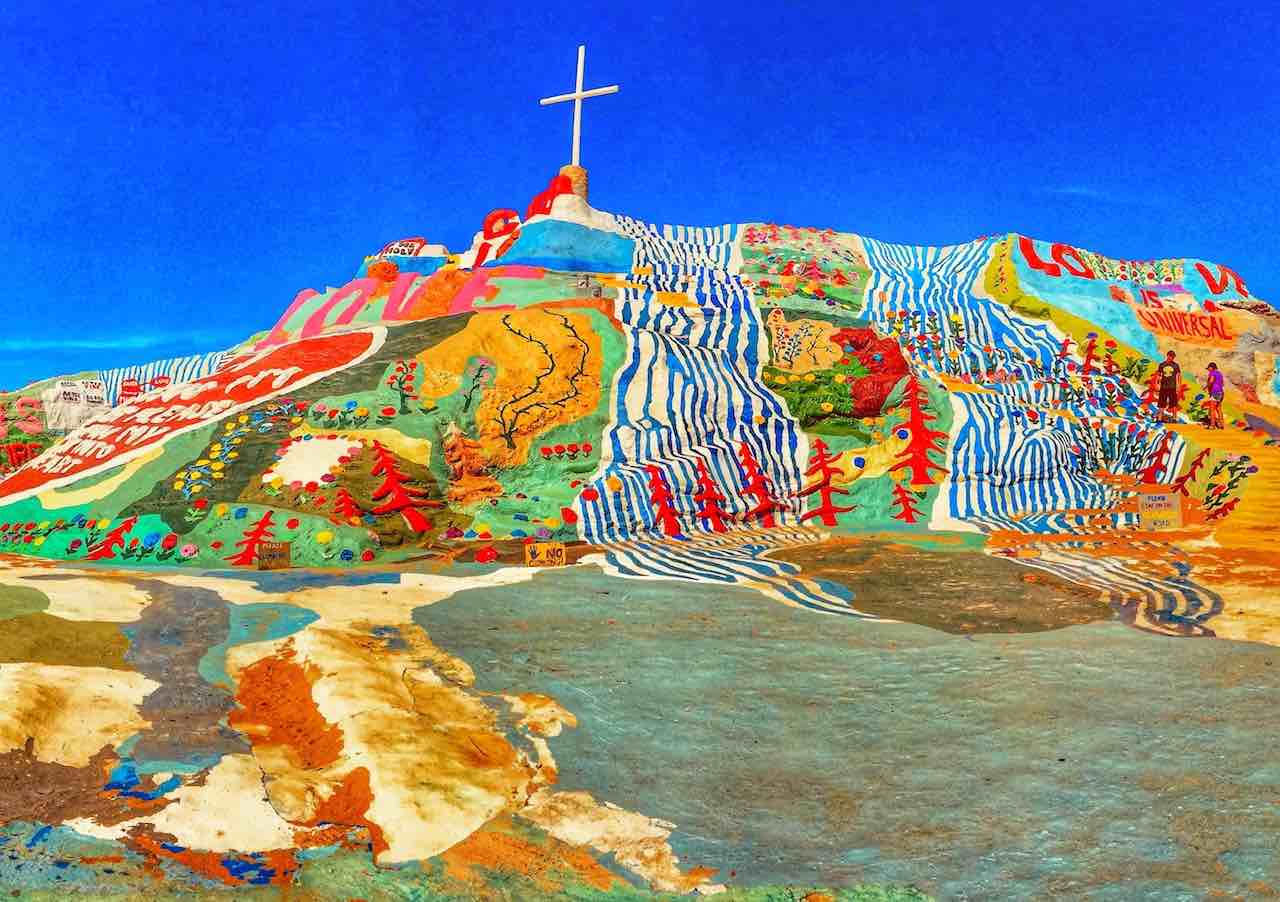
Salvation Mountain
SHOPPING | CONTACT | NEWS | SUBSCRIBE ENG ITA ESP ENG ITA ESP Salvation Mountain, Slab City, California. What to do and see, how to get Salvation Mountain Share on facebook Share on pinterest Share on twitter Slab City, California is a place far from the usual. Once a military base, today it is a kind of village forgotten by God, without rules and without laws. Literally. Nomads. Hippie. Anyone who wants to escape from civilization and schemes, takes refuge in these parts. Not far from here rises Salvation Mountain, an incredible artificial mountain, with incredibly bright colors. American rockers Kyuss have immortalized it on their LPs. The place was also the set of some scenes of the feature film “Into the Wild”. It even appears in video game scenes. A cross and the words “God is Love” stand out at the top. This is the message that Leonard Knight wanted to leave to posterity, to whom we owe the monument. A mission of faith, love and hope. Knight would have spent his entire life building Salvation Mountain. A meticulous work, using any material at one’s disposal: straw, earth, bricks, concrete, telephone poles …. What appears today is a place of a thousand colors, including symbols, hearts and beautiful flowers. PRACTICAL INFO HOW TO GET TO SALVATION MOUNTAIN The place is located on Beal Rd, Calipatria, California, just over 100km from Palm Springs, and about a two and a half hour drive from San Diego. The latter is an excellent base for an excursion to the mountains. Especially for the distance from LAX, the Los Angeles international airport, one of the busiest in the United States. Take Interstate 10 and CA-111S. The total journey is about 200 miles, with a travel time of around 3 hours. From San Diego, however, travel along Interstate I-8, continuing on CA-111 N, for a total of approximately 150 miles. PRICES AND TIMES Access to Salvation Mountain is free. Today, the place is run by an association of volunteers: an offer at will would not be bad. Admission is allowed every day, including Sundays and holidays, from sunrise to sunset. WHAT TO DO AND SEE The visit of the place does not involve a particular expenditure of energy and effort, nor too much time. Through the marked path, you can reach the top and take beautiful photos. The mountain is particularly beautiful, with its bright colors. There isn’t much to see. In our opinion, it could be an excellent base for an excursion to combine with nearby Galleta Meadows. The latter offers a set of spectacular sculptures in the middle of the desert. It is about an hour and a half drive from Salvation Mountain. Related Leave a comment Latest Posts Map of the Place Share the Post Share on facebook Share on twitter Share on linkedin Share on pinterest Share on email